Mount Batur or in Bahasa Indonesia called Gunung Batur is an active volcano located at the center of two concentric calderas as a result of previous eruption in Bali Island, Indonesia. In line of north west of Mount Agung creating the Bali Island highlands which significantly influence the livings in Bali Island. The Batur caldera inhabited by 15 villages distributed inside and around the caldera outer line where the locals largely rely on agriculture for income. The fertile soils around Mount Batur supporting the agriculture industry in the area have significant correlation with the volcano eruption activities. And the Kintamani ridge at west side of Mount Batur become one of popular tourist destination for its perfect position for Mount Batur and surrounding caldera views.
Sunday, November 20, 2022
Wednesday, November 9, 2022
Indonesia Tourism Development Corporation (ITDC) Nusa Dua Bali
Indonesia Tourism Development Corporation (ITDC) or PT Pengembangan Pariwisata Indonesia (Persero) is an Indonesia state-owned enterprise that specializes in the development and management of integrated tourism complexes. One of the most successful work of ITDC is The Nusa Dua Resort in South Kuta District, Badung Regency, Bali Province. The Nusa Dua Resort nowadays is a world - renowned tourism complex the holiday island’s most coveted destination for its many upmarket international class hospitality brands.
Tuesday, November 1, 2022
Bali Province Population in 2022
 |
| Balinese women and girl are walking at touristic beach at Pantai Gunung Payung, South Kuta, Bali, Indonesia |
Saturday, October 29, 2022
Bali Island, The God's Islands In Indonesia Archipelago
Bali Province in Indonesia consists of a number of islands including Bali Island it self as the biggest island, Nusa Penida Island, Nusa Ceningan Island, Nusa Lembongan Island, Serangan Island which located at the southern part of Bali Island, and Menjangan Island which located at the west side of Bali island. All the islands known worldwide as the God's Islands in Indonesia Archipelago.
 |
| A Balinese temple near the Nusa Dua Resort Beach |
Friday, February 23, 2018
Samosir Regency Government
Previous Samosir Regency Brief History
Structurally, the Government of Samosir Island consist of Regency's Offices, Sub-District Offices, Rural Villages Offices and Urban Village Offices. All of the above offices are part of the Executive Offices. There is a Regional People’s Representative Council as Legislative Office. Both Executive and Legislative Offices of Samosir Regency are the main authority in the regency.
Samosir Regency Brief History
The implementation of Republic of Indonesia Law No. 22/1999 on Regional Government
and Law No.
33/1999 on Balance Fund between central and regional government
had motivated
people in some region to appear the aspiration to create a new
autonomy regency/city
government. People had a hope that, by realizing a new autonomy regency/city government will have
a chance more
widely to keep their own region in realizing the increasing of their
social welfare.
Sunday, February 18, 2018
Samosir Regency: Employment in 2016
Samosir Regency in Figure 2017 (Badan Pusat Statistik/BPS Kabupaten Samosir 2017) used the 2015 National Labor Survey (SAKERNAS) on August 2015 for the data of Samosir Regency Employment in 2017. The available labor force of Samosir Regency in 2015, basend on the survey is 70.272 people. It is 88,38 percents of the total population who have been reaching 15 years old and above. The Indonesian Law suggested that the labor force should have age of 15 years old and above. For the states institution, the maximum age is 58-60 years old. The total of labor force in 2015 who are working are 69.373 people. Unemployment in the same year are 899 people.
Samosir Regency: Population in 2016
Statistic
Office of Samosir Regency (Badan Pusat Statistik/BPS Kabupaten Samosir)
in Samosir Regency in Figure 2017 mentioned that Samosir Regency
Population in 2016 is 124.496 people. Consist of 61.904 males and 62.592
females. In percentage, males is 49,72% and females is 50.28 % of total
population. A published book or data of Regency or City in figure
usually used the previous year of the date of book or data published.
Samosir Regency in Figure 2017 will described the data of 2016.
Saturday, February 10, 2018
Humbang Hasundutan: Population Distribution Based on Age Group and Sex
Previous Humbang Hasundutan: Population Distribution
Humbang Hasundutan Regency population distribution based on Age Group and Sex in 2016 as described in Humbang Hasundutan Regency in Figure 2017 ( Statistic Office of Humbang Hasundutan Regency, 2017) are below:
Humbang Hasundutan: Population Distribution
Previous: Humbang Hasundutan: Population
Humbang Hasundutan population distribution described as demography or the structures of the population in the regency area. Population distribution based on household, age groups, and etc. An information about population distribution is important to determine a condition of an area based on the population structures.
Humbang Hasundutan in Figure 2017 (Statistic Office of Humbang Hasundutan Regency, 2017) described the population, household and average of household based on subdistrict as below.
Wednesday, January 31, 2018
Humbang Hasundutan Education: Senior High School
Senior
High School in Indonesia consist of Sekolah Menengah Umum (SMU)/Senior High
School and Sekolah Menengah Kejuruan (SMK)/Vocational Senior High School.
Commonly, a student have to pass 6 grades in Sekolah Dasar (SD)/Elementary
School then continue to Sekolah Menengah Pertama (SMP)/Junior High School. 3
grades in Junior High School have to pass before continue the education to
Senior High School or Vocational Senior High School.
Tuesday, January 30, 2018
Humbang Hasundutan: Education
Previous Humbang Hasundutan: Population
The
Formal Education Level in Indonesia consists
of primary education, secondary
education, and high education.
The kind of education that
taught consists of general education,
vocational, academic, professional,
religious, and specific education.
·
The Primary Education consists of Elementary School and Islamic
Elementary School or other
equivalent forms and Junior
High School and MTs, or other
equivalent forms.
Humbang Hasundutan: Population
Previous Humbang Hasundutan Regency: Weather
Humbang Hasundutan Regency in Figure 2017 (Humbang Hasundutan Statistic Office, Badan Pusat Statistik (BPS) 2017) describe that Humbang Hasundutan
population based population projections for 2015 were 182.991. They are consisting
of 90.790 male and 92.201 female. Compares with the total
Humbang Hasundutan Regency Population in 2014, the Population growth of Humbang Hasundutan are
1,09 percent. The magnitude of the sex ratio in 2015 the male population towards the female
population are 98,47.
Sunday, December 31, 2017
Humbang Hasundutan: Weather
Previous Humbang Hasundutan Regency
Humbang Hasundutan in Figures 2017 (Badan Pusat Statistik/BPS Humbang Hasundutan, 2017) mention that Humbang Hasundutan Regency geographic position is Latitude between 2 Degree 1’ North - 2 Degree 28’ North , and Longitude between 98 Degree 10’ East - 98 Degree 58’ East. Due to the geographical position, Humbang Hasundutan Regency is in Tropical Climate Region. The climate is only dry season and rainy season.
Tuesday, December 19, 2017
Humbang Hasundutan Regency
Humbang Hasundutan is one of regency in Province North Sumatra. It is in central part of Province Sumatra Utara, in west of Medan City, the capital of North Sumatra. The regency lied closer to west coast of Sumatra Island, and also in west part of Toba Lake.
Geographically, Humbang Hasundutan is located between 2 degree 01’- 2 degree 28’ North latitude and 98 degree 10’- 98 degree 58’ East longitude. Humbang Hasundutan has boundaries as follows North - Phakpak Barat Regency and Samosir Regency, East - Samosir Regency and North Tapanuli Regency, South - Central Tapanuli Regency and North Tapanuli Regency, West - Central Tapanuli Regency and Phakpak Barat Regency
Thursday, February 11, 2016
Samosir Regency: Education
Previous Samosir Regency: Population

As introduced in previous section, Indonesia education ministry had 'mandatory 9 years study' program but currently has planned to mandatory target 12 years study. The educational levels in Indonesia are from lowest to highest, Play Group, Kindergarten (Taman Kanak-kanak), Primary School (Sekolah Dasar/SD), Junior High School (Sekolah Menengah Pertama/SMP), Senior High School (Sekolah Menengah Umum/SMU) has the same level with Vocational Senior High School (Sekolah Menengah Kejuruan/SMK), College (Diploma I, II, III, commonly known in Indonesia as Akademi), University (Universitas) for Graduated and Post Graduated Education has the same level as Institute (Institut) and High School (Sekolah Tinggi).
Wednesday, February 10, 2016
Samosir Regency: Population
Population of Samosir Regency based on Samosir in Figure Book (2015) estimated about 123.065. It was the estimation projection for 2014 based on 2013 population data. Consisted of 61.080 males (49,63 % of total population) and 61.985 females (50,37 % of total population). Compared to the area of Samosir Regency 1.444,25 square kilometer, the density value is 85,21 population per square kilometers. The total population is covered from 29.759 households. It indicates that the average population per household is about 4,14. Population distribution per sub-district are as described below.
Tuesday, February 9, 2016
Samosir Regency: Weather
Previous Samosir Regency
Samosir Regency geographic position is
Latitude between 2 Degree 21’38’’ North - 2 Degree 49’48’’ North , and Longitude between 98 Degree 24’00’’East - 99 Degree 01’48’’ East. Due to the geographical position, Samosir Regency is in Tropical Climate Region. The climate is only dry season and rainy season. Elevation of Samosir Regency area is between about 904 meters to 2.157 meters above sea level. The lowest elevation of Samosir Regency area is influenced by Toba Lake water surface elevation. Toba Lake water surface elevation vary to the weather condition. A long dry season in the surrounding areas will influence the water run off from hills and mountains through rivers and streams along Toba Lake shorelines.
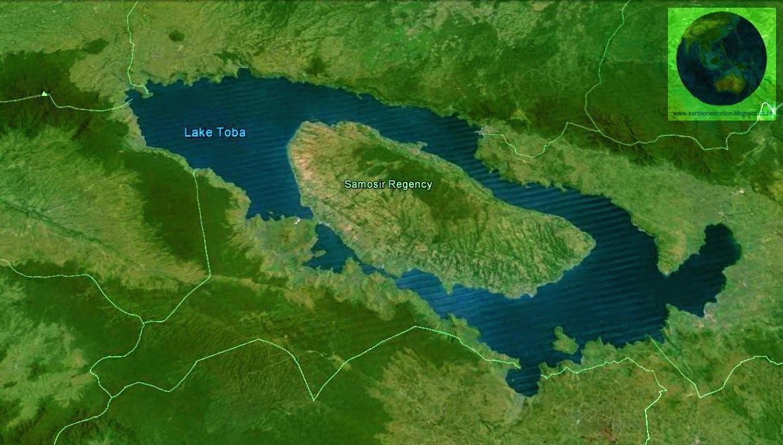
Samosir Regency
Previous Samosir Island

Samosir Regency is a regency in North Sumatra Province, Indonesia. Samosir Regency area consists of Samosir Island and west area of Toba Lake Caldera. Samosir Regency area was belong to Toba Samosir Regency which divided from North Tapanuli Regency. Most of Toba Highlands area was part of North Tapanuli Regency. Due to the developments and communities improvements reasons, North Tapanuli Regency divided to 4 regencies, they are North Tapanuli Regency as the origin regency, Toba Samosir Regency, Humbang Hasundutan Regency and Samosir Regency. Some opinion suggested that the regencies division represented the Batak sub-clan division, Silindung in North Tapanuli Regency, Humbang in Humbang Hasundutan Regency, Toba in Toba Samosir Regency and Samosir in Samosir Regency.
Monday, February 8, 2016
Sumatra Island

Sumatra Island is one of the biggest island in Indonesia. It is the third biggest island in Indonesia after Kalimantan and Papua. Sumatra is in western part of Indonesia as the most western Indonesia boundaries. In west of Sumatra is Indian Ocean or Samudera Hindia in Bahasa Indonesia, Java Sea and Malayan Peninsula in east, Andaman Islands, Malayan Peninsula and South Asia region in north, Java Island and South Java Sea in south.
Subscribe to:
Posts (Atom)