The implementation of Republic of Indonesia Law No. 22/1999 on Regional Government
and Law No.
33/1999 on Balance Fund between central and regional government
had motivated
people in some region to appear the aspiration to create a new
autonomy regency/city
government. People had a hope that, by realizing a new autonomy regency/city government will have
a chance more
widely to keep their own region in realizing the increasing of their
social welfare.
Showing posts with label North Sumatra. Show all posts
Showing posts with label North Sumatra. Show all posts
Friday, February 23, 2018
Saturday, February 10, 2018
Humbang Hasundutan: Population Distribution
Previous: Humbang Hasundutan: Population
Humbang Hasundutan population distribution described as demography or the structures of the population in the regency area. Population distribution based on household, age groups, and etc. An information about population distribution is important to determine a condition of an area based on the population structures.
Humbang Hasundutan in Figure 2017 (Statistic Office of Humbang Hasundutan Regency, 2017) described the population, household and average of household based on subdistrict as below.
Wednesday, January 31, 2018
Humbang Hasundutan Education: Senior High School
Senior
High School in Indonesia consist of Sekolah Menengah Umum (SMU)/Senior High
School and Sekolah Menengah Kejuruan (SMK)/Vocational Senior High School.
Commonly, a student have to pass 6 grades in Sekolah Dasar (SD)/Elementary
School then continue to Sekolah Menengah Pertama (SMP)/Junior High School. 3
grades in Junior High School have to pass before continue the education to
Senior High School or Vocational Senior High School.
Tuesday, January 30, 2018
Humbang Hasundutan: Education
Previous Humbang Hasundutan: Population
The
Formal Education Level in Indonesia consists
of primary education, secondary
education, and high education.
The kind of education that
taught consists of general education,
vocational, academic, professional,
religious, and specific education.
·
The Primary Education consists of Elementary School and Islamic
Elementary School or other
equivalent forms and Junior
High School and MTs, or other
equivalent forms.
Sunday, December 31, 2017
Humbang Hasundutan: Weather
Previous Humbang Hasundutan Regency
Humbang Hasundutan in Figures 2017 (Badan Pusat Statistik/BPS Humbang Hasundutan, 2017) mention that Humbang Hasundutan Regency geographic position is Latitude between 2 Degree 1’ North - 2 Degree 28’ North , and Longitude between 98 Degree 10’ East - 98 Degree 58’ East. Due to the geographical position, Humbang Hasundutan Regency is in Tropical Climate Region. The climate is only dry season and rainy season.
Tuesday, December 19, 2017
Humbang Hasundutan Regency
Humbang Hasundutan is one of regency in Province North Sumatra. It is in central part of Province Sumatra Utara, in west of Medan City, the capital of North Sumatra. The regency lied closer to west coast of Sumatra Island, and also in west part of Toba Lake.
Geographically, Humbang Hasundutan is located between 2 degree 01’- 2 degree 28’ North latitude and 98 degree 10’- 98 degree 58’ East longitude. Humbang Hasundutan has boundaries as follows North - Phakpak Barat Regency and Samosir Regency, East - Samosir Regency and North Tapanuli Regency, South - Central Tapanuli Regency and North Tapanuli Regency, West - Central Tapanuli Regency and Phakpak Barat Regency
Thursday, February 11, 2016
Samosir Regency: Education
Previous Samosir Regency: Population

As introduced in previous section, Indonesia education ministry had 'mandatory 9 years study' program but currently has planned to mandatory target 12 years study. The educational levels in Indonesia are from lowest to highest, Play Group, Kindergarten (Taman Kanak-kanak), Primary School (Sekolah Dasar/SD), Junior High School (Sekolah Menengah Pertama/SMP), Senior High School (Sekolah Menengah Umum/SMU) has the same level with Vocational Senior High School (Sekolah Menengah Kejuruan/SMK), College (Diploma I, II, III, commonly known in Indonesia as Akademi), University (Universitas) for Graduated and Post Graduated Education has the same level as Institute (Institut) and High School (Sekolah Tinggi).
Wednesday, February 10, 2016
Samosir Regency: Population
Population of Samosir Regency based on Samosir in Figure Book (2015) estimated about 123.065. It was the estimation projection for 2014 based on 2013 population data. Consisted of 61.080 males (49,63 % of total population) and 61.985 females (50,37 % of total population). Compared to the area of Samosir Regency 1.444,25 square kilometer, the density value is 85,21 population per square kilometers. The total population is covered from 29.759 households. It indicates that the average population per household is about 4,14. Population distribution per sub-district are as described below.
Tuesday, February 9, 2016
Samosir Regency: Weather
Previous Samosir Regency
Samosir Regency geographic position is
Latitude between 2 Degree 21’38’’ North - 2 Degree 49’48’’ North , and Longitude between 98 Degree 24’00’’East - 99 Degree 01’48’’ East. Due to the geographical position, Samosir Regency is in Tropical Climate Region. The climate is only dry season and rainy season. Elevation of Samosir Regency area is between about 904 meters to 2.157 meters above sea level. The lowest elevation of Samosir Regency area is influenced by Toba Lake water surface elevation. Toba Lake water surface elevation vary to the weather condition. A long dry season in the surrounding areas will influence the water run off from hills and mountains through rivers and streams along Toba Lake shorelines.
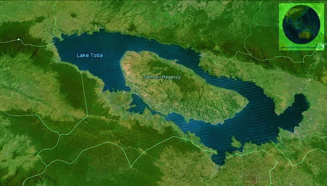
Samosir Regency
Previous Samosir Island

Samosir Regency is a regency in North Sumatra Province, Indonesia. Samosir Regency area consists of Samosir Island and west area of Toba Lake Caldera. Samosir Regency area was belong to Toba Samosir Regency which divided from North Tapanuli Regency. Most of Toba Highlands area was part of North Tapanuli Regency. Due to the developments and communities improvements reasons, North Tapanuli Regency divided to 4 regencies, they are North Tapanuli Regency as the origin regency, Toba Samosir Regency, Humbang Hasundutan Regency and Samosir Regency. Some opinion suggested that the regencies division represented the Batak sub-clan division, Silindung in North Tapanuli Regency, Humbang in Humbang Hasundutan Regency, Toba in Toba Samosir Regency and Samosir in Samosir Regency.
Monday, February 8, 2016
5. Toba Lake Surface Area

Toba Lake surface area measured based on the outer shoreline perimeter. Measurement using Google Earth polygon tool. Polygon tool created by click 'add polygon' tool at Google Earth toolbar. A Google Earth - New Polygon window will pop up, which named Untitled Polygon. Replace the name 'Untitled Polygon' with any name you want to tag your new polygon. Then use the mouse to create the points of the polygon perimeter. Google Earth automatically will calculated the perimeter length and the polygon area. The calculation will be showed in Measurements Tab below the polygon name. You can choose which unit will be used in the calculation. The units available are centimeters, meters, kilometers, inches, feet, yards, miles, nautical miles, smoots, degrees, arc second. Below is the image of Toba Lake polygon measurement.
Saturday, February 6, 2016
Samosir Island

Samosir Island is an island in Toba Lake. Toba Lake is a lake in Sumatra Island, Indonesia. It means that Samosir Island is an island in Sumatra Island. This unique earth feature, an island in an island was a result of geological process in Sumatra Island. Geological studies in Toba Lake indicated that the area was a super volcano which erupted about 75.000 years ago.
The eruption released thousand meters cubic of ash to air, throwing it until thousand kilometer from it's origin place. Created a big holes on the earth that now known as Toba caldera. The geological progress beneath the hole continued to push the earth mantle upward, resulted an uplifted land on it. Slowly, water filled the hole until reached the Toba caldera maximum capacity to current lake water level. The land on the caldera center is known as Samosir Island.
Friday, February 5, 2016
4. Toba Lake Outer Shoreline Distance

Toba Lake outer side shoreline measurement shows the measurement between two point of outer side shoreline of Toba Lake. Toba Lake is lenghtwise from North-West to South-East direction. It's form is oval and have narrow part in the center area. Based of the direction, the position is vertically from north to south area. The images below show the length and width of Toba Lake based on the outer side shorelines.
3. Samosir Island Distance to Toba Lake Shoreline
Previous 2. Samosir Island Length and Width
The farthest distance of Samosir Island to outer side of Toba Lake is in north part of Toba Lake. This north area is the largest part of Toba Lake. It is estimated that the deepest point of Toba Lake is around this north area. The farthest distance is about 24,28 kilometers length from northern part of Samosir Island to Karo Regency shoreline. The images below show the farthest and shortest distance from Samosir Island to outer side Lake Toba shoreline.
2. Samosir Island Length and Width
Previous 1. Samosir Island Area
Samosir Island formed almost the same as the Toba Lake form. It is lenghtwise from North-West to South-East. The island parallel to east and west caldera side. The northern and southern tips of Samosir Island is narrower than the center part. The most narrowest part is in northern tip and the wider part is in the center part.Below images show the measurement result of Samosir Island Length and Wide.
1. Samosir Island Area
Previous Toba Lake Facts Measured Using Google Earth
Samosir Island is an island in the center of Toba Lake. The island estimated created due to the geological process beneath the Toba caldera. The magma and gas tension beneath the Toba caldera pushed the earth mantle upward and created a land in the centre of Toba Lake named Samosir Island. The Samosir Island estimated as the weakest part of the Toba caldera earth mantle. The tension pushed Samosir Island land resulted the deepest area in Toba Lake to about 500 meter depth.
Sunday, January 31, 2016
Facts about Toba Lake
Previous Toba Lake in North Sumatra, Indonesia

Toba Lake is a volcanic lake in North Sumatra Province, Indonesia. It is the biggest lake in Indonesia and South East Asia. The lake's water isolated by Toba Caldera that keep the water inside the caldera. An outlet stream of Toba Lake water is by Porsea in Toba Samosir Regency. The stream flow the Toba Lake water trough Asahan River to East Coast of North Sumatra in Asahan Regency. Some pictures captured from Google Earth show the measurement of Toba Lake area using Google Earth measurement tools. Some facts measured using Google Earth about Toba Lake area.
Thursday, January 28, 2016
Toba Lake
Toba Lake
Toba Lake is a volcanic lake in North Sumatra, Indonesia. Lied in central area of North Sumatra Province, surrounding by chain of mountains that named Bukit Barisan in Indonesia. Based on World Lake Database data, Lake Toba is 905 meters above sea level, 529 meters maximum depth and 1.100 square kilometers surface area. There are some islands in the lake, the biggest is Samosir Island, the second is Sibandang Island and 8 smaller islands. North Sumatra is one of the Indonesia province in Sumatra Island.
Subscribe to:
Posts (Atom)