Bali Province in Indonesia consists of a number of islands including Bali Island it self as the biggest island, Nusa Penida Island, Nusa Ceningan Island, Nusa Lembongan Island, Serangan Island which located at the southern part of Bali Island, and Menjangan Island which located at the west side of Bali island. All the islands known worldwide as the God's Islands in Indonesia Archipelago.
 |
| A Balinese temple near the Nusa Dua Resort Beach |
Geografically, the area of Bali Province is 08º03'40" - 08º50'48" South Latitude and 114º25'53" - 115º42'40" East Longitude. Bali Island and the small islands around it administratively is a province in Indonesia, know as Province of Bali. Bali borders in east side is Lombok Strait and West Nusa Tenggara Province, in west side is Bali Strait and East Java Province, in North side is Bali Sea and in south is Indian Ocean.
 |
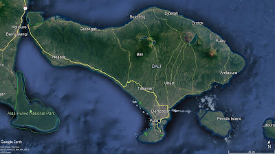
Bali Island border with East Java Province in Java Island and Lombok Island in Nusa Tenggara Barat Province (Source: Google Earth) |
Based on Bali in Figures, 2022, the total area of Bali is 5.780,06 sq,km, consists of 1 city and 8 districts. Denpasar city, the only city in Bali is the capital of Province of Bali. The province of Bali districts are Jembrana District with it's capital Negara, Tabanan District, the capital is Tabanan, Badung District, the capital is Mangupura, Gianyar District, the capital is Gianyar, Klungkung District, the capital is Semarapura, Bangli District, the capital is Bangli, Karangasem District, the capital is Amlapura, and Buleleng District, the capital is Singaraja.
 |
Province of Bali in Bali Island (Source: Google Earth) |
Bali Province in Figure 2022 stated the total area of Bali Province is 5.780,06 square kilometer (sq.km). The areas divided by Jembrana District 841,80 square kilometers, Tabanan 1.013,88 sq.km, Badung 418,62 sq.km, Gianyar 368,00 sq.km, Klungkung 315,00 sq.km, Bangli 490,71 sq.km, Karangasem 839,54 sq.km, Buleleng 1.364,73 sq.km and Denpasar City 127,78 sq.km. The biggest district is Buleleng District with 1.364,73 square kilometer width or 23,61% of the Bali Province area. And the smallest one is the capital of Bali Province, Denpasar City which has 127,78 square kilometer width or only 2,21% of the Bali Province area.
Read Also:
Regencies and city in Province of Bali, Indonesia
Denpasar City, the capital of Bali Province
Badung Regency, the richest district in Bali for tourism industry
Bangli Regency, the only district in Bali Island which have no beach area
Buleleng Regency, the largest district in north Bali
No comments:
Post a Comment