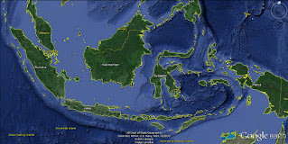
Indonesia is an archipelago country in South East Asia Area. The archipelago laid between Asia Mainland in North and Australia at South, Pacific Ocean in East and Indian Ocean in West. Geographically, Indonesia position is around 6 Degrees North and 11 Degrees South, around 95 Degrees East to 141 Degrees East. The latitute position indicated that Indonesia is crossing by Equator line.
Showing posts with label Indonesia. Show all posts
Showing posts with label Indonesia. Show all posts
Wednesday, January 27, 2016
Indonesia Archipelago
Indonesia is an archipelago country in South East Asia Area. The archipelago laid between Asia Mainland in North and Australia at South, Pacific Ocean in East and Indian Ocean in West. Geographically, Indonesia position is around 6 Degrees North and 11 Degrees South, around 95 Degrees East to 141 Degrees East. The latitute position indicated that Indonesia is crossing by Equator line.
Tuesday, January 26, 2016
Earth Carved
When I was working for a nickel mining
company in East Halmahera, North Moluccas Province, i had a chance to
explore nearby earth. East Halmahera is a regency in North Moluccas
Province. The regency is in Eastern part of Halmahera Island. The capital of East Halmahera Regency is Maba. A coastal city in East Halmahera Bay. Maba consists of two village, Maba and Maba Sangaji village. There are some small islands in East Halmahera Bay. And a lot of reefs which just a few meters below the sea surface. Most of the small islands have sandy white beaches. Only some of the small island have population that live in it, mostly are not inhabited.
Saturday, January 23, 2016
Earth Carved 01
Stripes Pattern Rocks
The power of the earth that can change earth surface condition. Earth moving direction can be horizontally or vertically or both directions to diagonally moving direction. The earth surface moving caused by dynamic progress inside the earth mantle. Pictures below showed the change that caused by external power of the earth. It involved sun radiation, water movement, wind power and direction.
Friday, January 22, 2016
North Sumatra, Indonesia
 |
| Indonesia Archipelago (Source: Google Earth) |
Read more about North Sumatra cities and regencies in Cities and Regencies in North Sumatra, Indonesia
Earth carved 02
Previous Earth Carved By the water power
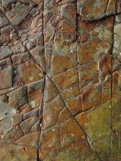
Irregular Patterned Rock
Previously explained that the unique coloring and patterning stones found in Boay Peninsula near Wailukum Village, East Halmahera Regency. Boay Peninsula also known as Manitinting for the locals. The stones form square, rounded, layered and onion like structure. The exposed part is at east of the hill that covered by high tide seawater. It can be reached in low tide period. The sea waves and fresh water from the top of the hill erode the the soils, causing the stones exposed to surface. And the exposed part have steep sloping.
Saturday, January 16, 2016
Thursday, January 14, 2016
The Globe
The Globe
Map
Map or Chart created to show a location, position, situation or condition that the map creator intended to show in the Map or the Chart. Using Map or Chart someone will know the position and then determine the orientation. Map or Chart can be a diagram, a sketch or a digital.
Subscribe to:
Posts (Atom)


